


Articles/Essays – Volume 46, No. 3
Joseph Smith, Captain Kidd Lore, and Treasure-Seeking in New York and New England during the Early Republic
Editor’s Note: This article has footnotes. To review them, please see the PDF below.
In his 2003 Dialogue article, Ronald V. Huggins discussed the possibility that Joseph Smith’s ostensible encounter with the angel Moroni was the invocation of a long-held folk tradition of treasure guardians in a milieu of treasure seeking and folk magic in the northeast.Huggins concluded that “Smith must have learned of the [treasure-guardian] motif while helping his father dig for Kidd’s treasure and while studying Kidd’s life and lore as a boy.” Some Latter-day Saint scholars, however, maintain that the figure Moroni was a visiting angel, as has been represented in official LDS accounts.
Whether or not Moroni was an angel or treasure guardian may be important in determining the derivation of Joseph Smith’s Book of Mormon character and otherworldly messenger, but perhaps more provocative is whether Smith’s two-decades long encounter with the treasure-seeking worldview had any influence on his role as translator. What did Joseph Smith know about Captain William “Robert” Kidd and other pirates operating in the East Indian Ocean? How would he have obtained such information? This article examines the transmission of tales and published accounts of Captain Kidd (some of which may have been accessible to Joseph Smith) and the possibility that he appropriated place names that appear in the Book of Mormon and pre-1830 maps, atlases, and geographical texts. Does the Book of Mormon contain language that might reflect Smith’s youthful preoccupation with Captain Kidd and his hidden treasure?
Scholars have well established that the prevalent use of folk magic and divining practices in New York and the New England states for the search of buried treasure was motivated by Captain Kidd’s legend and other pirate lore. Folklorist Wayland Hand and historian Alan Taylor have written of both the pirate lore and the widespread, indefatigable pursuit of buried treasure as part of the prevailing supernatural economy in the Northeast—a pursuit that promised quick wealth and power over a supernatural world. Men and women of the poorer classes embraced treasure-seeking to counter the uncertainty and privation that accompanied the struggling new republic. Farmers and merchants living in the rural hinterlands resorted to using occult magic, necromancy, and divination to locate hidden pirate treasure. As historian W. R. Jones observed, “What the ubiquitous Captain Kidd did for the northern coasts, Morgan and Lafitte did for the south; and pro vocative place-names such as ‘The Gold Fields’ near Stratford, Connecticut, and ‘Money Hill’ on the beach at Providencetown pointed to places to dig.”
Following the discovery of a portion of Kidd’s treasure on Gardiner’s Island, New York, in 1699, treasure seekers began to scour the coastline and inlets of New Jersey, New York, Connecticut, Rhode Island, and Long Island Sound.So dogged was the search for Captain Kidd’s buried loot during the early decades of the nineteenth century that many unburied, unfilled holes riddled the New England countryside as remnants of unsuccessful digs. The New York Constellation reported that, in the quest for Kidd’s elusive treasure, “acres of ground have been dug, three fathom deep, for its discovery. In various places may be seen large pits still yawning as proof of the prevalent belief in this buried treasure, and as mementos of the credulity and the avarice of mankind.”An 1817 New York Daily Advertiser article described the widespread pursuit of Kidd’s treasure thus:
The belief in the existence of treasures secreted in different parts of the coast, is to this day prevalent in a great part of the southern shores of New England, and many adventures have attempted to discover his secret hoards. Magical practices are attributed to him for their preservation, and Beelzebub himself is confidently declared to be leagued with the famous pirate, and to keep watch on the lid of his iron chest to deter the attempts of daring avarice.
One traditional account asserted that Kidd’s vessel was chased up the Hudson River by some English men-of-war. In order to elude capture, those on board set fire to the ship and escaped with what they could carry, leaving behind the largest portion of the gold and silver on board the wreck, which sank at the entrance to the Highlands.An Albany newspaper reported in 1823 that Kidd found a prominent landmark to hide his loot:
During his piratical career, he visited Coeymans and Albany, and had a secret place of retirement on or near a hill about two miles south of Albany, (and which still bears his name, viz. Kiddenhooghten, or, as it is improperly called, Kittenhooghten.) That hill, according to tradition, he adopted as a place of rendezvous for those infernal spirits, to whose care he entrusted the enormous sums of money, which he buried in the earth.
These stories resulted in countless treasure digs in the hills and shorelines along the Hudson River and in the Catskills south of Albany. For many years, superstitious mountain dwellers of the Catskills often spoke of imps, ghosts, and the “‘spook’ that guards the money-chest of Captain Kidd.”
One short, adventurous story of a treasure dig, published in 1832, stated that “there was a belief prevalent at that time, among many of the good people of New-England, that the noted Kidd had in one of his cruises ascended the Connecticut, and buried, on its numerous islands, immense treasures of his hoarded booty.”A Windsor, Vermont, newspaper article, reprinted in the Palmyra Register in 1825, told of many locals pursuing Captain Kidd’s treasure in the Upper Connecticut River Valley (sometimes known as the Upper Valley): “We are sorry to observe, even in this enlightened age, so prevalent a disposition to credit the accounts of the marvelous. Even the frightful stories of money being hid under the surface of the earth, and enchanted by the Devil or Robert (Captain Kidd), are received by many of our respectable fellow citizens as truths.”The article continued, “A respectable gentleman in Tunbridge, in that state, was informed, by means of a dream, that a chest of money was buried on a small island in Agar’s brook, in Randolph. No sooner was he in possession of this valuable information, than he started off to enrich himself with treasure. After having been directed by the mineral rod where to search for the money, he excavated to the depth of 7 or 8; and all the while it was necessary to keep six pumps running to keep out the water.” According to this published account, his companions arrived to assist him in uncovering the chest. When one of the company drove an old file through the rotted lid of the chest and perceiving it to be nearly empty, exclaimed with a gripe, “‘There’s not ten dollars apiece!’ No sooner were the words out of his mouth, than the chest moved off through the mud, and has not been seen or heard of since.”As was illustrated by this story, it was believed that pirate treasures, under guard of a ghost or goblin, were sometimes elusive, or “slippery” when disrespectfully handled.
Of this group of treasure hunters in Randolph and Tunbridge, Vermont, Joseph Smith Sr. (also said to have been affected by vivid dreams) may well have been a member prior to his arrival in Palmyra in 1816. Historians D. Michael Quinn and John L. Brooke have suggested that, during his years living in Tunbridge, Royalton, and Sharon (and possibly during a brief residency in Poultney), the elder Smith and William Cowdery, father of Book of Mormon witness Oliver Cowdery, were involved with a religious sect, founded in the 1790s by Nathaniel Wood and called the New Israelites, whose members also engaged in dowsing and other forms of divination to locate treasure. Members of the New Israelites began dowsing to look for buried treasure in Middle town and Rutland, Vermont, after the group was joined by a counterfeiter and treasure seer named “Winchell” (believed to be Justus Winchell) in the spring or early summer of 1800. Although it is difficult to place Smith in Rutland County, Vermont, during that particular time, Quinn and Brooke cite evidence that he was a member of this circle of treasure hunters and was one of its “leading rodsmen.”A letter inserted into the 1870 volume of Historical Magazine by Daniel Woodard, former judge of the Windsor County Court and relative of Beniah Woodard, stated that “Joseph Smith, Sr. was, at times, engaged in hunting for Captain Kidd’s buried treasure; and he also became implicated with one, Jack Downing, in counterfeiting money, but turned State’s evidence and escaped the penalty.”
In 1857, historian Charles Elliot reported that
No unimportant man has caused more fear, speculation, and gold digging, than Captain William Kidd. Along the shores of New England and Long Island, from his day to this, men have dug in the dead of night, directed, as they thought, by the witch-hazel, or the divining-rod, to find his buried Gold: and none have found it.
Tales of searching for Kidd’s gold booty included not only the use of divining rods and pacts with the devil, but also the guidance of treasure dreams, incantations, mesmeric trances, and professional treasure seekers to assist in finding the buried loot using a magic parchment, stone, or hazel rod.In one documented incident, Abraham Gardiner Thompson, a leading New York merchant, recalled using a divining rod and conjuring incantations from Barrett’s Magus, or Celestial Intelligencer (1801) to search for Captain Kidd’s treasure.
In the early decades of the nineteenth century, stories containing literary motifs of buried treasure, pirate ghost ships, and old buccaneer curses entered the corpus of American fictional writing with such tales as Washington Irving’s “The Devil and Tom Walker” (1824), James Fenimore Cooper’s The Water Witch (1830), and Edgar Alan Poe’s “The Gold-Bug” (1843), all conceived in the atmosphere of the Kidd legend that pervaded New York and the New England states.
Treasure Seekers in Palmyra
One published treasure-digging story tells of “An Old Rods man” who was born in Westport, Massachusetts, and had grown up in a seafaring family. He eventually developed his own life on the water as commander of various boats, spending the better part of his time on dry land searching for buried treasure with a divining rod. Identified only as “the Commodore,” the subject of the story spent his youth accompanying fisherman in their small coasters off the shores of Nantucket and Martha’s Vineyard.
The region which gave him birth was prolific in witch stories, and all along the coast abounded in legends of pots and chests of money secreted by the pirates, who once infested these seas, amongst which the names of Captain Kidd and Captain Low were pre-eminent. His maternal grandfather had in his possession a musty old manuscript, describing the location where some of these pots of treasure were hid, given him by Captain Low, who died at his house, and finally fell into the hands of “the Commodore,” kindling in his youthful mind an insatiable desire for the discovery of hidden wealth, that time could never extinguish.
After several trading expeditions to the West Indies as a young man, the Commodore moved to Sidney, Maine, on the Kennebec River, where he followed his favorite pursuits: fishing for salmon, shad, and herring during the spring months, while making occasional fishing voyages the rest of the season to St. John’s Island (now Prince Edward Island) and the mouth of the St. Lawrence River, and selling his catches at fish markets in Boston. It was on the Kennebec that he made his first attempts at digging for Kidd’s pirate treasure in the sands along the bays, inlets, and islands near the mouth of the river. After many years unsuccessfully searching for buried treasure at spots in Portland Harbor and Casco Bay, such as Jewel Island and the shores from the mouth of the Connecticut to Penobscot, he decided to move inland. “In the year 1813, he transported his wife and children across the State of New-Hampshire and Vermont, to the town of Palmyra, in New York. Here he passed a year in cultivating the earth.”Although he moved to Marietta, Ohio, in 1816, the Commodore undoubtedly left his treasure-seeking influence on the area’s Kidd devotees.Mormon genealogist Thomas L. Revere and historian John L. Brooke concluded that the man known as “the Commodore” was probably Stephen Davis, born in Westport in 1777.
Other Kidd treasure seekers in the Manchester/Palmyra area were known to associate closely with the Smith family. Dr. Luman Walters of Sodus Township was a close friend of Joseph Smith Sr. and was linked to the Palmyra circle of treasure hunters. Walters, known as “the magician” and “a juggling fortune teller,” reportedly possessed “strange books” and is believed to have spent time in France to be trained in Mesmerism and the occult.According to a later reminiscence, Walters was adept at “reading the mind and being able to tell people where they could find lost articles, friends and the future.”Like Walters, Smith family friend Samuel Tyler Lawrence also used folk magic to find hidden treasure. Lawrence assisted Joseph Smith Sr. and his son in identifying dig sites in Ontario County, including a hill near Manchester (later known as the Hill Cumorah). According to Joseph Knight, a close friend of the Smiths in Palmyra, Lawrence “was a “Seear [seer] and he had Bin to the hill and knew about the things in the hill and he was trying to obtain them.”Lorenzo Saunders, another Smith family friend and former resident of Palmyra, remembered that Smith Jr. took Lawrence to Harmony, Pennsylvania, in 1826 to look for treasure on the banks of the Susquehanna River and was first introduced to Emma Hale by Lawrence while there. William R. Hine, a resident of Windsor, New York, recalled hearing from the younger Smith that “he [Smith] saw Captain Kidd sailing on the Susquehanna River during a freshet, and that he buried two pots of gold and silver. He claimed he saw writing cut on the rocks in an unknown language telling where Kidd buried it, and he translated it through his peepstone.” Hine also remembered that Smith had dug for silver ore, under the employ of Asa Stowell, on Monument Hill, “over a year without success.” Then, presumably with Lawrence, “he dug for Kidd’s money, on the west bank of the Susquehanna, half a mile from the river.”
Could someone like Stephen Davis, the ascribed seer Samuel T. Lawrence, or the professed conjurer and treasure-seeker Lu man Walters have planted in the minds of Palmyra residents the legendary tales of Captain William Kidd and his exploits in the Mozambique Channel, near Madagascar and the Comoro Is lands?
If Joseph Smith Sr. wasn’t the first to bring enthusiasm and knowledge of Kidd treasure lore to the Manchester/Palmyra neighborhood, then these individuals may well have informed and fueled the telling and retelling of the Kidd tales. Historians know very little about Walters and Lawrence except for their pursuit of Captain Kidd’s treasure and their use of folk magic and divination to find it. According to Abner Cole, editor of the Palmyra Register, “The mania of money digging soon began rapidly to diffuse itself through many parts of this country; men and women without distinction of age or sex became marvellous wise in the occult sciences, many dreamed, and others saw visions disclosing to them, deep in the bowels of the earth, rich and shining treasures.”Cole’s series of newspaper articles were written in jest, but they were as revealing as they might have been had they been written as informative local news briefs. His satirical mockery of the area’s treasure seekers disclosed Walters’s methods of divination and occult magic for locating buried treasure:
Mineral rods and balls, (as they were called by the imposter who made use of them,) were supposed to be infallible guides to these sources of wealth—“peep stones” or pebbles, taken promiscuously from the brook or field, were placed in a hat or other situation excluded from the light, when some wizzard or witch (for these performances were not confined to either sex) applied their eyes, and nearly starting their balls from their sockets, declared they saw all the wonders of nature, including of course, ample stores of silver and gold.
Walters eventually moved to Gorham and opened a medical practice in a former tavern on Main Street. He became a trusted doctor in that area and was known to employ Thomsonian medicine, using roots and herbs “which he compounded into medicine at his laboratory.”According to Abner Cole, once Walters left the Manchester/Palmyra neighborhood, “his mantle fell upon the prophet Jo. Smith Jun.”
Beginning sometime around the year 1820, Joseph Smith Jr. and his father reportedly spent some of their efforts looking for “hidden treasures” on and in the vicinity of “Miner’s Hill” and “Robinson’s Hill” near Palmyra, at “Bend Mountain” near Harmony, Pennsylvania, and at “Monument Hill” in Windsor, New York.Robinson’s Hill, known to present-day Latter-day Saints as the “Hill Cumorah,” is situated on what used to be the property of Randall Robinson, about two miles south of the Wayne/Ontario County line, on the east side of the Canandaigua Road.John Hyde reported in 1857 that “it was quite common in the western part of New York, about thirty years ago, for men to dig for treasure which they supposed had been hidden by Captain Kidd and others. Many plans were tried and much imposition practiced by means of divining-rods, dreams, and seeing-stones. It was not at all a new thing for Smith, therefore, to pretend to the power of seeing where gold was by the use of a ‘peep-stone,’ nor did it surprise the inhabitants of that locality.”Orrin Porter Rockwell, the Smiths’ Manchester neighbor and longtime friend of Joseph Smith Jr., told Elizabeth Kane in the 1870s that “not only was there religious excitement [near Palmyra], but the phantom treasure of Captain Kidd were sought for far and near, and even in places like Cumorah.”Another contemporary of Joseph Smith named Daniel Hendrix stated in an 1899 interview that “Joe had dug and dug there for gold for four years, and from that time the hill has been known as Gold Hill.”
By the time Robinson’s Hill became known as “Gold Hill” (and later Cumorah), the hills and countryside near the Smiths’ Manchester farm bore scars of Joseph Smith-inspired treasure digs. As late as 1867, Manchester and Palmyra residents reported seeing unfilled pits, indicating that Smith or other members of the Palmyra circle of treasure seekers had been there. In the 1830s, open and empty pits could still be seen on properties owned by Josiah Stowell and Abner Cole. Other neighborhood residents remembered that Smith and his father had dug for treasure on the properties owned by Peter Ingersoll, Joshua Stafford, and Joseph Capron. It was also reported that Joseph Smith Jr. searched for treasure on land owned by Joseph McKune Jr. in Harmony, Pennsylvania.
In light of Joseph Smith’s idolization of Captain Kidd and pursuit of pirate treasure, some scholars have thought that his use of a name similar to that of the Indian Ocean’s Comoro Archipelago (a favorite pirate haunt) in his translation of the Book of Mormon is evidence that he borrowed it from an early map or geographical text. Even more strikingly coincidental to these scholars is Smith’s use of the name “Moroni,” which is also the governing town of the island of Grande Comore (or Grand Comoro), the largest of the Comoro Island group.
The Comoro Islands and Camorah
The Comoro Islands, located northwest of Madagascar in the Mozambique Channel, were convenient places of anchorage for merchant vessels on their way to India from Europe.Comprising four islands—Ngazidja (Grande Comore or Grand Comoro), Mahoré (Mayotte), Mwali (Mohéli or Mohilla), and Nzwani (Anjouan or Johanna)—the island group was frequently visited by Dutch, Portuguese, French, and English traders in the seventeenth and eighteenth centuries.By the mid-seventeenth century, the Comoro Islands were considered a pirate stronghold, a place where marauding sea bandits would hide their booty. In 1660, the world traveler Vincent Le Blanc referred to the four-island group as “the Isles of Theives [sic].”
According to pirate chronicler Charles Johnson, Captain William Kidd and his crew of the Adventure Galley cruised the Comoro waters in the summer of 1696, “touching sometimes at the island of Mohilla, and sometimes at that of Johanna, between Mala bar and Madagascar.”After a short time, Kidd careened the Galley at Johanna to obtain provisions and repair the ship.During this time, he did not exhibit any intention of turning pirate, for “near Mohalla and Joanna both, he met with several Indian ships richly laden, to which he did not offer the least violence, tho he was strong enough to have done what he pleas’d with them.” However, fearing that he would be out of work for his failure to capture pirates, Kidd went looking for merchant ships to take. Within a few months, however, Kidd was indicted for murdering one of his ship’s crew and overtaking a 350-ton Indian merchant vessel, the Quedagh Merchant, which was navigating twenty-five leagues off the shores of Cochin (present-day Kochi) in the Arabian Sea. Under order of the Earl of Bellmont, governor of the provinces of New York, Massachusetts Bay, and New Hampshire, Captain William Kidd was apprehended, tried, and ultimately hanged on May 23, 1701.
In Joseph Smith’s account of the retrieval of the gold plates, Moroni, the Book of Mormon prophet, appeared to him as an angel or heavenly messenger and directed him to the place where the ancient Nephite record was buried.The plates were buried in a stone box in a prominent hill near the Smith family home— later identified as Cumorah. In the Book of Mormon narrative account, the plates were deposited into a stone box somewhere on the western brow of this hill.
The first instance in which the word Cumorah or “Camorah” is used in the Book of Mormon is in Mormon 6:2: “And I, Mormon, wrote an epistle unto the king of the Lamanites, and desired of him that he would grant unto us that we might gather together our people unto the land Camorah, by a hill which was called Camorah, and there we would give them battle” (1830 edition, p. 529).According to the narrative account, the final Nephite/ Lamanite battle would take place at the hill: “And it came to pass that we did march forth to the land of Camorah, and we did pitch our tents round about the hill Camorah; and it was in a land of many waters, rivers and fountains.” Thus, some 384 years after the coming of Christ to America, the Nephites gathered the remain der of their people “unto the land Camorah” to face the Lamanites in a battle of extermination.
Given Joseph Smith’s well-known and documented digs for Captain Kidd’s treasure, it gives one cause to wonder if the Book of Mormon names are derived from his treasure-seeking worldview. If they are not, then the association of Grand Comoro and its capital town Moroni with William Kidd and other pirates is a striking coincidence. If they are, then Joseph Smith’s use of the names Camorah and Moroni in the Book of Mormon was, quite possibly, his boldest anachronistic use of words—a cryptic nod to his favorite seventeenth-century pirate.
Print Sources for Captain Kidd and His Piracy on the Indian Ocean
With all the talk of wealth and hidden stores of silver and gold, it is little wonder that excitable men and women of Palmyra indulged in recounting tales of ancient riches and buried pirate treasure and resorting to folk magic in order to find the bounty. Much of what was transmitted verbally may well have been read in newspapers or chapbooks, or shared by travelers and neighbors. Pomeroy Tucker and other Palmyra neighbors remembered that young Joseph Smith read adventure stories and the lives of rogues and criminals, including the legendary Captain Kidd.Palmyra resident Philetus Spear wrote that Smith “had for a library a copy of the ‘Arabian Nights,’ stories of Captain Kidd, and a few novels.”In an 1881 interview on the origins of Mormonism, Anna Ruth Eaton, another of Smith’s Palmyra neighbors, counted “the redoubtable Captain Kidd” as Smith’s “hero,” saying that he had “the autobiography of Capt. Kidd, the pirate. This latter work was eagerly and often perused.”
Even though these recollections exist, it is widely believed that Joseph Smith was unbookish or illiterate. Smith’s mother wrote that her son “had never read the Bible through his life,” and though he exhibited considerable insight for a boy eighteen years of age, “he seemed much less inclined to the perusal of books than any of the rest of the children, but far more given to meditation and deep study.”Smith could have traveled less than five miles to the Farmington (Manchester after 1823) library to use its collection of more than 270 books, but scholars have dismissed this as a source of printed information for the Book of Mormon because Smith did not have a library subscription or membership.The young man was known to regularly purchase the Pal myra Register for his father and later the Wayne Sentinel, but many historians are unwilling to speculate as to whether he actually read them.Some maintain that Smith simply did not have access or means to purchase books for a personal reference library. For example, John W. Welch contends that “those who have considered western New York as the information environment for the Book of Mormon may be 120 miles or more off target. One should think of Joseph translating in the Harmony [Pennsylvania] area and, as far as that goes, in a resource vacuum.”
It is not surprising that Mormon scholars dismiss the idea that their founding prophet-leader was literate. Painting the image of the “Boy Prophet” as an unlearned and simple plowboy mythifies him and places him on equal status as Old Testament youthful prophets Samuel, Daniel, and David. Even Smith’s biographer Richard Bushman has perpetuated the widely held notion that Smith’s more erudite associates such as Sidney Rigdon were “more likely to have read widely than poorly educated and unbookish Joseph Smith.”
Still, as economically deprived as the Smith family may have been, there is no reason to believe that Joseph Smith was so destitute that he could not afford a handful of books and pamphlets to read and carry with him. Scholars of private libraries and book ownership have discovered that even families in the lowest economic ranks kept a modest selection of books in their homes. When news was not transmitted by word of mouth, members of rural New England and New York communities obtained information from newspapers and chapbooks purchased in local book stores.Publishers and printers used subscription agents, traveling peddlers, and chapmen to sell their books in more isolated reaches of the country. The dissemination of knowledge in the early republic was primitive but not inhibited by the various modes of pre-industrial transport.
Before the coming of a comprehensive railway system, canal transportation improved book distribution in New York’s pre-industrial economy. By 1825, when the newly completed Erie Canal passed through the villages of Palmyra and Macedon, the water way was already proving an economic boon to Rochester and other cities near its course.Within a year of the canal’s inauguration, Rochester, a mill town known for its flour production, was home to scores of mercantile and dry goods stores supplied by canal boats and packets from New York and Boston. At least three bookstores were supported by shipments of books from printers in New York City, Philadelphia, Boston, Cooperstown, and Albany.It could not have been more fortuitous that the Smith home in Palmyra was less than three miles from the canal, which put young Joseph Smith well within reach of a wide selection of books, maps, and pamphlets. The Cooperstown publishing partnership of brothers Henry and Elihu Phinney, for example, carried an assortment of books—“a variety beyond that found in ordinary village bookstores”—from New York and Philadelphia and distributed them with their own publications through towns and villages from large wagons with moveable tops and counters, even providing a floating bookstore on the canal.In 1824, another canal boat named The Encyclopedia of Albany, owned by Elisha Wilcox of Albany, embarked upon the waterway, featuring a bookstore and lottery office. According to a published announcement in the Palmyra Register, the boat would “move up and down the canal, bearing the riches of science as well as the gifts of fortune, to their respective favorites.”A subsequent article described the unique enterprise:
It is used as a bookstore and lottery office, and contains about two thousand well selected volumes, and a quantity of stationary. It is accompanied by two wagons, for the purpose of extending their trade to those villages, which are a short distance from the canals. The owners sell for money where they can find purchasers, but they calculate that a barter for rags will be the principal part of their trade.
An announcement in Palmyra’s Wayne Sentinel boasted, “Traveling Stores have already passed this place on the canal, and from accounts in eastern papers, we may expect soon to be visited by a Floating Museum, which is now on its way to the west.’”As de scribed in the Cooperstown Watch-Tower, the canal boat Superior, also owned by Wilcox, promoted a bookstore as well as a museum:
The Bookstore apartment is furnished with a general and well-selected assortment of books, maps, engravings, plays, &c, &c. The Museum contains a great variety of minerals, birds, sea shells, wax figures of celebrated characters, quadrupeds, together with many ancient relics of warfare, both from the aborigines of America, and of the orientals.”
If one of the floating bookstores didn’t have what a discriminating reader wanted, the village printer might have a selection of charts and bound volumes for sale. From the summer of 1818 through 1820, the Palmyra bookstore and print shop—then own ed by Timothy C. Strong—boasted no fewer than two hundred books for sale, including biographies, travel narratives, and geographies that would have noted the islands of the East Indian Ocean, including Nathaniel Dwight’s A Short but Comprehensive System of the Geography of the World (1795), Jacob Cummings’s Intro duction to Ancient and Modern Geography and its accompanying at las (1813), and Jacob Willetts’s An Easy Grammar of Geography and atlas (1814).
The long-held perception that Smith was “unlearned” or “unbookish” cannot be supported by the notion that printed material was unavailable to him. Despite Lucy’s statement downplaying young Joseph’s reading habits, it is possible that he was more attuned to reading materials than Mormon scholars have long believed. Dr. John Stafford, a Palmyra resident who lived a mile from the Smiths, remembered Joseph as being “quite illiterate,” but he also remembered that Lucy had aspirations for her children and began to homeschool the children. “After they began to have a school at their house, he improved greatly,” said Stafford.
Bushman has written that, although books were available to Joseph Smith, “we must question the assumption that availability means access or dependence.”However, Joseph Smith’s donation of thirty-eight imprints to the Nauvoo Library and Literary Institute in 1844 shows that he was interested in the subjects of theology, philosophy, literature, and travel narratives. A donation of this number of imprints is reason to consider the size of Smith’s larger collection, what it included, and when it was begun. Interestingly, in addition to Volume 1 of Orville Dewey’s Old World and the New (1836) and Captain John Dennett’s Voyages and Travels of Captains Ross, Parry, Franklin, and Mr. Belzoni (1835), Smith donated a volume of the noted Danish geographer Conrad Malte-Brun’s Annales des Voyages (1808–14), which contained descriptions and travel accounts from all over the world.
If, in fact, Joseph Smith had an “autobiography of Captain Kidd” in his possession and read it, then what would have been the title of that volume? What other sources on Kidd and other pi rates would have been available to him? The first and perhaps the most in-depth biographical work on Kidd appeared in print after the pirate’s trial and execution in 1701. The eight-page pamphlet, entitled An Account of the Birth, Parentage, Education, Life and Conversation, of Captain William Kidd, the Late Famous English Pirate, was published by R. Owen in London that same year.Five other imprints giving an account of the proceedings of Kidd’s trial and execution were written in 1701 as well. This included one booklet published in Dublin by an anonymous author and entitled A Full Account of the Actions of the Late Famous Pyrate, Capt. Kidd (1701). A fifty-nine-page booklet, entitled The Arraignment, Tryal, and Condemnation of Captain William Kidd, for Murther and Piracy upon Six Several Indictments (1701), was published in London, along with a fifty-one-page account of the proceedings, sometimes attributed to Dr. John Mitchell, entitled A Full Account of the Proceedings in Relation to Capt. Kidd. In Two Letters (1701).Two abbreviated versions of the trial proceedings, each printed on a two-page broadsheet, were published in London; one was authored by the High Court of Admiralty, and the other, authored by Paul Lorrain, was the official Ordinary of Newgate account of Kidd’s execution.
One of the five trial accounts, The Arraignment, Tryal, and Condemnation of Captain William Kidd, contained a transcript of the court proceedings, including the testimony of one of the crew of the Adventure Galley, Robert Bradinham, the ship’s surgeon, who testified that Kidd and a crew of 155 men left New York in September 1696 and set sail for “the Madera’s from thence to Bonavis, from thence to St. Jago, from thence to Madagascar, from thence to Joanna, from thence to Mahala, from Mahala to Joanna again, and from thence to the Red-Sea; and there we waited for the Mocca Fleet.” Bradinham’s testimony was particularly illuminating, since, although he did not mention the Comoros as a group, he named Mohilla and Johanna as Kidd’s places of anchorage, before heading out to the Arabian Sea to lie in wait for the Mocca fleet (Moorish ships) of which the ill-fated Quedagh Merchant was a member.
A more likely biographical book in Smith’s possession was Charles Johnson’s General History of the Pyrates, published in 1724, considered the most thorough treatment of the lives of rogues and pirates to date. However, a biographical treatment of William Kidd did not appear as part of Johnson’s compilation until 1728, when Johnson published a second volume entitled The History of the Pyrates.This follow-up to his General History of the Pyrates soon became one of the most widely read and most influential published works on Captain Kidd and his pirate counterparts of the Golden Age of Piracy (ca. 1650–1730). If Joseph Smith had a copy of this 1728 second volume of Johnson’s General History of the Pyrates (or the American edition, published in Haverhill, Mas sachusetts, in 1825 by Thomas Carey), he would have read of the exploits of all the major pirates of the Atlantic, East Indian, and Arabian oceans, including Captain Nathaniel North who, as a crewman in a band of privateers, captured the eighteen-gun brigantine called Pelican off the shores of Newfoundland. While the privateer obtained a commission to attack French holdings in West Africa, he instead traveled to Madagascar where he searched for Moorish ships to capture.
From Augustine they went to Johanna, and the provisions they had salted at Madagascar not being well done, it began to spoil; this, and their clothes wanting Repair, made them desperately resolve to take the king of Johanna and make him ransom himself, but the Master wou’d not take charge of the ship, being unacquainted with the coast. They cruised among the islands, landed at Comaro, and took the Town, but found no Booty, excepting some Silver Chains, and check’d Linen. From hence they went to Mayotta, where they took in a Frenchman who had been marooned there, and maintain’d by the King.
Johnson’s compilation of biographical narratives of Kidd and other pirates who stalked the waters of the East Indian Ocean was the most comprehensive available in the 1820s. Though the other biographical treatments name Madagascar, Johanna, and Mayotta as pirate haunts, this was the first mention of a pirate being in the vicinity of Comoro (“Comaro”), the larger island. Other than Johnson’s History of the Pyrates, only a handful of newspaper articles published in New York and the New England states helped spread the tales of Kidd and his exploits on the eastern seaboard and the East Indian Ocean. A variously published and widely distributed ballad printed in form of a broadside, The Dying Words of Captain Kidd, did as much to heroicize Kidd, as did Johnson’s His tory of the Pyrates, but a number of short biographical sketches in newspapers introduced William Kidd to New England states and New York.For example, in 1822, a two-part biographical sketch, published by Sampson Braughton in the New England Galaxy, told of Kidd traveling “to the Indian ocean and establishing himself somewhere upon the Island of Madagascar” where he “lay like a shark in those remote seas, pillaging and plundering with impunity the commerce of all nations at his pleasure.”Several other biographies followed, but they appeared long after Joseph Smith’s departure from Harmony, Pennsylvania, where most of the translation of the Book of Mormon was said to have taken place.
Geography Texts, Charts, Maps, and Atlases as Sources of Knowledge of East Indian Ocean Pirates and the Comoro Islands
Published tales of roguery and buried pirate treasure would not have been Smith’s only sources of information for Captain Kidd and the Indian Ocean. As historians Dennis and Geoffrey Wright have pointed out, Joseph Smith’s “early public schooling may have played a more important part in preparing him for his prophetic role than previously supposed.”Smith would have been taught customary lessons in world history and geography as part of his common school education in Vermont’s Upper Valley and western New York. In addition to instruction in languages, mathematics, philosophy, reading, rhetoric, astronomy, and arithmetic, select schools and academies in Palmyra and surrounding villages offered classes in geography and mapping.One Samuel Danforth of Rochester, for instance, offered instruction in drawing maps “of the several countries, together with the Globe,” for the small sum of three dollars, saying:
It is to be lamented that so many people of our country are impressed with an idea that a knowledge of Maps, and the relative situations of countries, (which ought to be the primary study of every student in Geography,) is of small importance. Many people take upon themselves much trouble in collecting Historical books of every description, and will peruse them for years; but unless they are acquainted with Geography, history will remain a confused mass of uninterested matter.
Citizens of the young American republic were quickly aligning themselves with a burgeoning sense of nationalism. In his essay “On the Education of Youth in America” (1787), Noah Webster called for better geographical texts to show America’s place in the world and to foster in young minds a feeling of pride in the newly formed republic.Professor of English and material culture historian Martin Brückner observed:
Geography textbooks, a genre that conditioned the literary sensibilities of early American readers, answered Webster’s call most closely. Aiming to educate as well as entertain, the first generation of United States school geographies exploited textual strategies that infused geography with ideas of setting and character; just as the traveler’s and natural historian’s own prose, self-consciously or not, mingled utilitarian, narrative, and affective priorities, so did geography books.
The proliferation of atlases and geography texts showing the national map served to popularize and exalt the image of the new republic in the global landscape.In keeping with this widespread feeling of nationalism, Albany author and publisher Amos Law serially advertised maps of the state of New York, the New England states, and Upper and Lower Canada in the Palmyra Register, saying that these and others “have met with very liberal patronage and encouragement.”A sudden, steady increase in the production and sale of new geographical texts not only resulted in a feeling of nationalism but also a growing preoccupation with owning and studying geographies, maps, and atlases.
Standard geography textbooks and dictionaries often contained catechizing questions and answers or descriptions of obscure countries, states, and cities, including Africa, Asia, and small island kingdoms. This interrogatory and sometimes informational approach was not only meant to inform the young reader, but provide texts for memorization and oral recitation. Other texts, designed simply for imparting knowledge to the student, came in the form of a geographic writing manual or geographic encyclopedia. For example, John Pinkerton’s Modern Geography (1804) gave an in-depth description of the land and people of Madagascar, and then described the smaller African islands of Comoro thus: “The islands of Comoro are four in number, of considerable size, particularly Angaziza, or the greater Comoro. That of Anzoan has a convenient harbour, sometimes visited by ships passing to India.”This description was nearly identical to that found in Benjamin Davies’s A New System of Modern Geography (1805).Jedidiah Morse’s The American Universal Geography (1805) offered a slightly more expanded description, stating that the Comora Islands
are a cluster of islands in the Indian Ocean, between the coast of Zanguebar and the north part of the island of Madagascar. They are four in number, viz. Johanna, Mayotta, Mohilla and Comora, which last is six leagues long and three wide, and gives its name to the group. It has no safe harbours. Its high mountains are richly covered with verdure and fruit trees, and give rise to numerous fertilizing streams, on which are many beautiful cascades. The vallies between the mountains are extensive, and in richness and beauty are exceeded by none in the world.
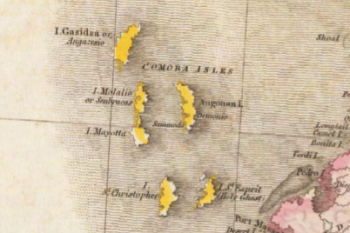
Three years later, Morse published his New Gazetteer of the Eastern Continent (1808), which gave brief descriptions of European, Asian, and African states and kingdoms, including a description of the “Comora Islands” identical to the one in the American Universal Geography. It contained a detailed sketch of the island of Johanna and its principal town, which was based on the accounts of Captains Hamilton, Walker, and Grose.Elijah Parish’s A New System of Modern Geography (1814) gave another nearly identical description to those of Pinkerton and Parish, indicating that they were all working from the same sources.Interestingly, Pinkerton’s A Modern Atlas (1815) included a detailed map of Southern Africa and Madagascar. The Comoro Islands were labeled “Comora Isles” and the greater island was labeled “I. Gasidza or Angazesio” (see fig. 1).A geography text by J. Bain, entitled Brookes’ General Gazetteer Improved (1815) gave a brief description of Comoro:
ANGAZIZA, ANGAZYA, ANGAREJA, or GREAT COMORO, the largest of the Comoro islands, is situated in the channel of Mozambique, between the northern extremity of Madagascar and the African coast, from which it is 210 miles distant. It is inhabited by Moors, and is governed with the other islands, by Pagan or Mahometan chieftans, who are tributary to the Portuguese. E lon. 43 58, S lat. 11 44.
Two school texts by Nathaniel Dwight, A Short but Comprehensive System of the Geography of the World (1813) and A New System of Universal Geography for Common Schools (1817), offered catechizing questions and answers to the geographical locations of smaller African Islands, including the Comoro group.Another geography text, Travels at Home (1816), contained directions and descriptions of the exotic African islands, as if the imaginative young student reader were taking a virtual tour across the Mozambique Channel, from Madagascar to Melinda, and then on to the Arabian Gulf:
The coast of Africa, which it washes, has the same term applied to it.—As we sail, the Comoro Isles are on our right hand, and cannot be noticed further than by saying that one of them, Johanna, has an excellent harbour, visited by ships that frequent the Indian Ocean. It is governed by a sovereign, who is friendly to the English, and the in habitants, or some of them, speak a little of our language after a bro ken fashion.
The atlas published for Woodbridge’s Rudiments of Geography (1824) showed the Comoro Islands without delineating the names of the four in the group (fig. 2). A common reference work, Carey’s School Atlas (1820, reprinted in 1825), showed Comoro in the Mozambique Channel with the other islands in the archipelago, but did not give town or place names on the largest island (fig. 3). The maps of Southern Africa in Jedidiah and Sidney Morse’s Modern Atlas (1828) and Samuel Griswold Goodrich’s At las (first published in 1830) meant to accompany Malte-Brun’s A System of School Geography (1830) showed the islands in the channel without place names as well (see figs. 4 and 5).
Many of these geography texts and atlases would have been readily available in school reference libraries or for sale (after 1822) at Palmyra’s Wayne County Bookstore. The proprietors, Pomeroy Tucker and John H. Gilbert, were even known to lend books to trusted patrons.The Dwight and Morse texts were two of several geography texts listed among the books available in Palmyra from 1823 to 1824.One recurring bookstore advertisement listed maps as an item for sale along with its general literature and school texts.Morse’s The American Universal Geography (6th ed., 1812) was also available in the Manchester Library within five miles of the Smith farm, although it is unlikely that Joseph used the collection.
Another source for geographical descriptions of the Comoros would have been published voyage accounts, travel logs, and diaries. Unfortunately, their usefulness in informing New England and New York treasure seekers of the exploits of East Indian Ocean pirates was extremely limited. While some of them described the geography, native culture, and prospects for trade, many travel narratives gave accounts of inter-island hostilities, South African incursions for the slave trade, and depredating Malagasy invasions.European travel accounts were largely published in French and Dutch, so they would not have satisfied the curiosity of the young Joseph Smith. However, there were a handful of these travel narratives that were published in London and New England, translated from the French and Dutch accounts.
One of the earliest eighteenth-century English travel narratives gave an observant account of the geography and inhabitants of the Comoro Islands. Scottish sea captain, privateer, and merchant Alexander Hamilton (not to be confused with the author of the Federalist Papers), while serving as commander of the Bombay Marine, traveled widely to the Barbary Coast, East Indian Ocean, and Arabian Sea to suppress piracy. In 1727, Hamilton published one of the earliest and most informative descriptions of the East Indies and Southeast Asia. Of his trip to the Comoro island group, Hamilton wrote:
Comora is the Westmost of the inhabited Islands, and affords nothing but a scrimp Maintenance for a Parcel of poor miserable Creatures. Johanna is within Sight of Comora, and is a plentiful Island in Cattle, Goats, Fowls and Fish, with good Lemons and Oranges, so that most Part of the English Shipping bound to Mocha, Persia and Surat, usually call’d there for Refreshments, till the Pirates began to frequent it.
This unfavorable description of the larger island appears to be a common perception of those who visited it, or heard of its unapproachable shoreline and inhospitable natives. For instance, Captain John Henry Grose, who visited the Comoro Islands in 1750, attributed the hostility of island inhabitants to the Portuguese who had mistreated them on their first visits:
COMRO, the largest island, is not at all frequented by the Europeans; because it has no safe harbor, or roadstead to it: besides, the natives have the character of a barbarous, untractable people, that will suffer no commerce with strangers. Perhaps too, not without rea son: as it was common for the Portugueze especially, in the early times of their navigating those seas, to take the advantage of the simplicity of the inhabitants, unacquainted with arms, and incapable of defence, and land parties out of their vessels, to rob, and commit all manner of outrages on the natives, not unfrequently carrying them away as slaves; a procedure, which may have given them a traditional aversion to, and jealousy of all strangers in general: and very probably the revenge they might thereon take on the next comers, without distinction of the innocent, may have gained them that inhospitable character, which is to this day continued to them.
An 1813 English edition of Abbé Raynal’s history of trade to the West and East Indies described the Comoro Islands and disclosed the ill temperament of the natives. Like Grose, Raynal thoughtfully stated that the reason for the inhospitality of the natives was due to the maltreatment by the Portuguese who were the first to visit the island:
These islands, that lie in the Mozambique channel, between the coast of Zanguebar and Madagascar, are four in number; Comora, the principal one, from which the small archipelago takes its name, is little known. The Portuguese, who discovered it in the course of their first expeditions, brought the name of Europeans into such detestation by their cruelties, that all who have since ventured to go on the shore there have either been massacred or very ill treated. It has accordingly been quite forsaken.
Raynal’s account of the natives’ treachery was supported by Henry May’s visit to the islands in 1591 on the Edward Bonaventure, one of three tall ships sailing to the East Indies. After anchoring for a time at Quitangone on the mainland of Africa, the ship’s crew sailed into the Mozambique Channel and
went for an island called Comoro, upon the coast of Melinde, which standeth about 11 degrees to the South of the equinoctical: in which island we stayed all November, finding the people blacke and very comly, but very treacherous and cruell: for the day before we de parted from thence they killed thirty of our men on shore, among whom was William Mace our master, and two of his mates.
As the years passed, British academicians and naval explorers stopped short of describing the larger island because of its abrupt and sometime treacherous shoreline. Orientalist Sir William Jones visited the Comoro Islands in 1799, giving extensive observations on the customs and manners of the inhabitants of Johanna, but did not offer a description of Grand Comoro.An extract from the 1809 journal of Captain Thomlinson, although it gave another splendid description of Johanna, did not mention the larger island, other than to tell of the Malagasy incursions to procure slaves by longboat:
The other islands, Comoro, Mohilla and Mayhotta, are nearly depopulated from the attacks of these marauders, and at this time Johanna from twelve towns is reduced to two. These pirates come over at the latter part of the south-west monsoon, build huts round the towns, which are walled, and remain blockading them until the latter end of the north-east monsoon, which occupies a period of eight months, as they never attempt the passage but with a fair wind.
In the first decades of the nineteenth century, more travelers visited the Comoros archipelago to describe the geography and native culture. A lengthy essay in French on the Comoro Islands by Messrs. Capmartin and Epidariste Colin was published in Conrad Malte-Brun’s Annales des Voyages in 1811 but only focused its description of the favorite island at which to stop for supplies—Johanna.Several years earlier, however, during his assignment at Madagascar, Count Benyowski of Poland spent a considerable amount of time describing the influence of the Sakalava on the islands. His discussion of Malagasy contact with Comoro included a description of the goods and services available at Maronvai, on the western coast of Madagascar:
The Arabians of the islands of Johanna, Comoro, and Mayotto, have established a factory at Maronvai, the capital of the Seclaves, which is at all times supplied with effects and merchandizes, consisting of Surat cloth, combs, silver bracelets, gold buckles, razors, knives, glass beads, &c. in exchange for which they receive skins, incense, benjamin, amber, wax, and wood in planks.
Although Benyowski described the king’s aversion to direct trade with the French, he did not mention the Comorian villages that supplied the materials for the Maronvai factory.
In 1819, Sir James Prior published an account of his travels to the east coast of Africa, the Mozambique Channel, and Comoro Islands in 1812, while in the capacity of surgeon on the Royal Navy frigate Nisus, under the command of Captain Beaver. His description of the largest island is illuminating in regard to the terrain and accessibility by boat, but offered nothing about the inhabitants or the names of its major villages:
Comoro, which gives its name to the group, is the largest and most mountainous, but not so fertile, it is said, as the others. The interior is very little known to Europeans, and, fortunately, as little to its enemies; and, probably, by its rugged surface, as well by the abrupt nature of the coast, has been preserved from the Madegasse invasions. About sixty years ago it was usually visited by English shipping, in the manner Johanna now is, but possessing no safe anchorage, became deserted for the latter, and at the same time the seat of government, which had always been there, was also changed.
The eighteen-volume collection, A General History and Collection of Voyages and Travels (1824), compiled and edited by Robert Kerr, contained four accounts by Alexander Sharpey of the East India Company’s fourth voyage to the islands off the East African coast in the fall of 1608. The two ships employed for the voyage, the Ascension and the Union, separated at the Cape of Good Hope due to darkness and storm; the Ascension continued a course through the Mozambique Channel, “encountering two or three small islands on the 22d November in the morning, and that after noon came to another off a very high land called Comoro.”
Sending our boat ashore on the 24, the people met five or six of the natives, from whom they bought plantains. The 25, by the aid of our boat towing the ship between two islands, as the wind would not serve, we came to anchor in the evening near the shore of Comoro, in between 17 and 20 fathoms water.
The subsequent narrative detailed the interactions of the ship’s crew with the king and trading gifts and courtesies with the natives. Although the inhabitants of the island village were described, the place name was never offered:
When at the town, the natives brought us cocoa-nuts for sale, of various sizes, some big as a man’s head, each having within a quantity of liquor proportioned to its size, and as much kernel as would suffice for a man’s dinner. They brought us also goats, hens, chickens, lemons, rice, milk, fish, and the like, which we bought very cheap for commodities; as two hens for a penny knife; lemons, cocoa-nuts, and oranges for nails, broken pikes, and pieces of old iron. Fresh water is scarce, being procured from holes made in the sands, which they lade out in cocoa-nut shells as fast as it springs, and so drink.
Later voyages of the English East India Company were published in the ninth volume of Kerr’s General History. The commander of the tenth voyage, Thomas Best, described the crew’s visit to the Comoro Islands in August of 1612, but only mentioned coming into sight of Mohilla and Mayotte. The company’s twelfth voyage was under the command of Captain Christopher Newport, and the journal was kept by Walter Peyton, who logged their anchorage at Mohilla and their sight of Johanna in the distance. Captain Peyton visited Mohilla again on his way to India in 1615, and gave a brief observation regarding the largest of the is land group: “Angazesia [Comoro] bears N. by W. west from Mohelia, and is the highest land I ever saw. It is inhabited by Moors trading with the main and the other three eastern islands, bartering their cattle and fruits for calicos and other cloths for garments. It is governed by ten petty kings, and has abundance of cattle, goats, oranges, and lemons. The people are reckoned false and treacherous.”Richard Swan’s account of a voyage to Surat and Jasques in 1620 mentioned the company’s passing “between Johanna and Mayotta” on the return trip in January 1622, but gave no description of Grand Comoro.
Malte-Brun’s Universal Geography (1826) contained a very short but enlightening description of Comoro but still no mention of Moroni, its principal town:
Angazija, or great Comora, situated twenty-five leagues to the northwest of Anjouan, is a vast assemblage of mountains, the different groups of which have their bases very near the sea-coast, and all re-unite in a common summit, of from twelve to thirteen toises in height. It has no road, but many villages.
The twelfth volume of Brewster’s Edinburgh Encyclopaedia (1830) gave a thorough description of Johanna, but did not touch upon the historical or geographical highlights of nearby Comoro, other than to say that several Frenchmen had sought refuge on the island after assisting in the defense of Johanna in 1802.The Reverend William Elliot also gave an account of Johanna in 1830, but made no mention of Comoro or its villages.Captain W. F. W. Owen’s published account of navigating the waters northwest of Madagascar in the ships Leven and Barracouta in 1823 gives a full description of the geography and inhabitants of Johanna, but indicates that they “passed between Great Comoro and Mohilla,” on their way to Mozambique harbor.Captain Philip Beaver’s visit to the Comoros in 1812 is fully recounted in Smyth’s biography of Beaver, though it only describes his party’s welcome reception on the island of Johanna, the island’s pleasant climate, and the abundant produce and fertile soil there.
The paucity of travel narratives translated into English from French or Dutch meant that very few published descriptions of Grand Comoro and Moroni would have been available—much less intelligible—to young Joseph Smith Jr. Most of the aforementioned English descriptions of the Comoro Islands persisted into the mid-nineteenth century. For instance, James Bell’s A System of Geography (1832) contained a description of the “Comoras,” but was still dismissive of the accessibility of the largest island in the group:
Grand Comora, the principal of the group, is a primitive mountain of great elevation, rising abruptly from the sea. Comora has been abandoned by shipping, of late years, in favor of Johanna, or Hinguan, the anchorage at the latter place being more eligible, the watering more convenient, produce more plentiful, and, upon the whole, the people more civilized.
Aside from travel accounts, the various admiralty charts and seamen’s guides which were published in the late eighteenth and early nineteenth centuries contained directions for navigating the waters of the East and West Indies. Many of them not only included coordinates for reaching obscure island ports, but also contained illustrative charts, maps, and descriptions for making anchorage in these primitive island kingdoms. Perhaps one of the most comprehensive pilot guides to that date, The Oriental Navigator (1801), described the archipelago with unprecedented detail:
The Comoro Islands are four in number, viz. Comoro, which gives its name to the rest, Mohilla, Mayotta, and Johanna; they are all very high, and seen at a great distance in clear weather; the length of each of them is between 6 and 8 leagues; the breadth from 4 to 5; their in habitants, who are Mahometans, are the descendants of Arabs, and a courteous and civil people. COMORO, called also Angazicha, is the largest and highest of these islands; as you come near its western most point, you will descry a small round island, not unlike that at Johanna, which you must round, and steer along shore to the northernmost end of the island, to which you give a birth of 2 miles; when round the point haul in for the land, steering N. E. and N. E. by N. and when you bring a black bluff point S. by W. ½ W. and the easternmost land in sight E. by N. you may then anchor in 16 fathoms, sandy ground; here are reefs to the eastward and westward of you; lie your best bower to the westward for the fresh gales at S. W. you will lie about 1 mile at high water, and half a mile at low water from the shore.
When you are getting around the north point of the island, it is necessary you should hoist out all your boats in readiness for towing, as the high land totally excludes you from the Monsoon, and you are subject to nothing but calms and light airs, added to which there is a tide here which ebbs and flows to a prodigious degree.
Whereby, (says Captain C. W. Webber, Jun. of the Oxford, 1759) I found it extremely difficult to get in near enough to lay hold of anchor ground; for it is steep to, till you come upon the bank, which does not descend with an even or gradual declivity from the shore, but goes off almost perpendicularly at once; and close to it, before you get foundings with 30 fathoms, you will not be able to find ground with 70 or 80, which I believe is the case all around the island at the distance of 1½ mile, or 2 miles from the shore. The place of anchoring would be very dangerous was it liable to any gales of wind, but it is entirely sheltered from the Monsoon; and I believe there very seldom happens any gale of wind from other quarters strong enough to endanger a ship.
The island has plenty of very good bullocks, sheep, goats, or anges and lemons, plantains, &c. but there is a great scarcity of water, and near the King’s town; insomuch that I was obliged to send water from the ship for the use of my people on shore.
The following particulars concerning this island are taken from the log of the Suffolk captain C. Lewin who was there also in 1759.
Bearings at anchor in 24 fathoms, sandy ground off Comoro; King’s Town about two small miles E. ½ S. a black bluff point like two rocky islands, S. S. W. the easternmost land E. by N.
The town is large and full of cocoa-nut trees, with a fine smooth sandy beach before it; it is the only place where we could land; shoal water runs off about three quarters of a mile, and at low tide you can not come off with your boat. Whenever you see this town send boats a-head, for as the shore is bold in all other places, you would have no thoughts of foul ground off such a fine sandy beach.
The first soundings we had were 35, then 25 fathoms when anchored. Latitude observed in the road, 11° 18′ S. When you have 12 fathoms, you are close to the reef. We lay about a cable’s length too near the King’s Town, and had we continued longer at the island would have moved.
The people at Comoro are very civil; the price of bullocks, settled with the King, is from 4 to 6 dollars; there are here sheep, goats, &c. but no water to be had. The King offered cowries, rice, &c.
Of all the islands, Johanna, Comoro, and Mohilla, I give the preference to the latter.
Another guide, John Malham’s Naval Gazetteer (1812), de scribed many obscure islands including the Comoro group: “CO MORO, the same as COMORA which see. The island particularly called Comora, is in lat. 11 deg. 25 min. S, and the nearest of any of the islands so named to the coast of Mozambique. It is 14 leagues N W from Mohilla, and 20 W by N from Joanna.”In addition to Malham’s Naval Gazetteer, Robert Laurie and James Whittle published their East India Pilot in 1795 and John William Norie published his Complete East India Pilot in 1816.The most celebrated and influential nautical guide, however, was Captain James Horsburgh’s India Directory.The first part of Horsburgh’s Directory was published in 1809, he being paid one hundred Guineas by the Court of Directors; the second part was issued in 1811.The guide was followed by a collection of charts bound in a large two-volume folio entitled the East India Pilot, first published by Black, Penny & Co. in London in 1815 and released in several editions thereafter. Horsburgh’s nautical directory and charts were available in the United States in the 1820s in most major city bookstores and was also sold in smaller book and stationery stores.The description of Grand Comoro reads:
COMORO, the largest and highest of these four Islands, gives its name to the others, which are Mohilla, Mayotta, and Johanna: they are all very high, and may be seen at the distance of from 14 to 20 leagues in clear weather. The inhabitants are Mahometans, descendants of Arabs incorporated with Africans, and at present, they are generally found to be courteous and hospitable.
Comoro, called also Angazecha, is about 12 leagues in length north and south, and about 5 or 6 leagues broad. The anchorage at this Island is inconvenient, and water not easily procured; European ships, therefore, do not now visit it, though formerly they sometimes touched here for supplies.
The anchorage is at the N. W. part of the Island, said to be in lat. 11° 18′ S., about 1¼ or 1½ mile to the westward of Muchama- hola, the King’s Town, opposite to a small sandy beach, but it is not advisable for a ship to anchor under 30 or 35 fathoms water, for in this depth, she will be only distant from the breakers about 2 cable’s lengths.
This remark was given by Captain Webber, who was there in the Oxford, in 1759, and the bearings recommended for anchorage are, the easternmost point of land in sight East King’s Town, E. S. E., and the black rocky point S. by W. The Suffolk at anchor in 24 fathoms sandy ground, had the King’s Town, E ½ S. distant near 2 miles, the easternmost land E. by N., and a black bluff point, like two rocky is lands, S. S. W. Captain Mitcham says, a ship may anchor with the easternmost land in sight E. by N., and the black bluff point S. by W. ½ W., but these and the Suffolk’s bearings are probably too close for a large ship.
Excepting the anchorage at the N. W. end, the Island is generally steep, having no soundings at a small distance from the shore; there are, indeed, two bays called Ingando and Moroon, to the northward of the S. W. point, where the bottom is coral, and the depth 35 fathoms within a cable’s length of the breakers, but no vessel should anchor there.
If a ship intend to anchor at this Island, she ought to have the boats prepared to tow when the shore is approached, for she will be liable to baffling light airs and calms, the high land obstructing the regular monsoon, and the tides, which are strong, may be liable to drift her past the anchorage, if precaution is not taken to counteract their impulse.
The town is large, with many cocoa-nut trees, and a sandy beach before it; at low water a boat cannot land, as shoal water extends ¾ of a mile from the town, which is the only landing place. Steering for the anchorage, a boat should be sent a-head to sound, for the bank is steep, and the distance small, from 35 fathoms on its outer edge to 12 fathoms close to the breakers. Ships may be sheltered here from the southerly monsoon, but it would be dangerous were the winds to blow strong at any time from the north-westward; this, however, seldom happens, particularly during summer, when the southerly monsoon predominates. Bullocks, sheep, goats, and tropical fruits are plentiful, but no water to be procured.
In 1759, the price of bullocks was settled with the king, from 4 to 6 dollars each; and it is prudent to give him a present, when a supply is wanted.
It is high water at 4¾ hours, and the tide rises about 12 feet on the springs. The body of Comoro is in lat. 11° 32′ S. about lon. 43° 25′ E.
In the foregoing description, Horsburgh mentions two bays, “Ingando and Moroon.” The etymological origins of the word moroon or maroon could undoubtedly fill a lengthy volume. Though it is probably a derivative spelling of the Swahili words Itzanda and Mroni or Maroni, “Moroon” would have to be Horsburgh’s identification of what came to be known as Moroni Bay. The place name was evidently known to the founding settlers of Ngazidja and did not originate with Horsburgh. Horsburgh’s spelling may well have been based on phoneticized spellings or pronunciations from mariner diarists and visitors to the island whom he surveyed for his directory. While it may be that Hors burgh was using the term denoting desertion or isolation on an is land shore—a term with which many of us are familiar and which was used by Johnson in his History of the Pyrates—this explanation is unlikely, as chroniclers who documented the settlement and French colonization of the island referred to the sultan’s village (or king’s town) first as “Mouroni,” or “Mourouni,” then as “M’roni.”In Comorian, the village name means “In the Heart of the Fire,” for its proximity to Mt. Karthala, a notoriously active volcano. In any case, however, “Moroon,” would not have been a source name for Smith’s “Moroni.”
A more logical source, if any, for Joseph Smith’s knowledge of Grand Comoro and its sultan town, Moroni, would have come from Alexander Dalrymple’s cartographic work for the East India Company. Dalrymple preceded Horsburgh as the official hydrographer to the East India Company and published a collection of marine charts between 1774 and 1775. His first published collection comprised 83 plates with plans of ports spanning from South Africa to China and the Malabar Coast. This collection, chiefly created for the company and its pilots, also included charts illustrating the four islands in the Comoro Archipelago.One chart, entitled “Plan of the w. side of Comoro or Anga- Zecha,” showed the west coast of Comoro with the place names of “Muchamahola,” “Ingando” (Itzanda), and “Moroon” (Moroni), with depths and obstacles near their anchorages (fig. 6). The map is dated 1774 and was derived from the manuscript notes of one Alexander Sibbald, who wrote that he and the ship’s crew “found the People civilized and got 2 measures of cowries for a dollar.” A published explanation of the plans by Dalrymple further indicated that
This plan of part of Comoro was made in 1753, by Alexander Sibbald, mate of the St. Cecilia a country ship belonging to Bengal. Several of the Indiamen have visited this Island since then; 1759 the Suffolk, C. Lewin, and Oxford, C. Webber.
Dalrymple then included the account given by Lewin but did not provide any additional descriptions of the island.
Sayer and Bennet’s Oriental Pilot (1778), which was succeeded by Laurie and Whittle’s East India Pilot mentioned earlier, included a chart featuring Madagascar and the Comoro Archipelago in the Mozambique Channel. An inset map, “A Chart of the Comoro Islands,” showed the inlets “Ingando” and “Maroon” on the west side of Comoro, “the Highest Island” (see fig. 7). Credit for the chart was given to the geographer and cartographer, Jean-Baptiste Bourguignon d’Anville, who relied heavily on previous cartographers and voyagers to create a new reliable map of Africa in 1749.
Aside from nautical charts like those by Dalrymple and d’Anville, school atlases would have been more accessible to the young Smith in Palmyra, but the virtual absence of any place names on plates showing Grand Comoro and its sultan village eliminates them as possible sources for Book of Mormon place names. Even the common atlases such as Colton’s Atlas of the World (1856) showed the Comoro Islands, but did not identify Moroni (fig. 8).
The name of the village did appear, perhaps for the first time in an atlas, in Garnier’s 1860 map of southern Africa in his Atlas Sphéroïdal et Universel de Géographie (1862).Garnier’s plate at tested to the fact that the sultan town, Moroni, was well known by Dutch and French traders many years before the publication of the Book of Mormon (see fig. 9). Belgian geographer Philippe Vandermaelen, for example, produced a six-volume atlas, Atlas Univérsel de Géographie (1827), which was the first and most comprehensive of its kind in the world.Vandermaelen, founder of the Brussels Geographical Institute, garnered high praise for his atlases and globes, not the least of which was the Atlas Universel. It included a plate showing Northern Madagascar and the Comoro Islands, including physical topography showing unprecedented detail of the Grand Comoro coastline and interior in relief (see fig. 10).
French travelers brought great knowledge of the East Indian islands to the West. Lequével de Lacombe’s visit to Grand Comoro in 1828 was published in a compilation of his travel accounts, Voyage à Madagascar et aux Iles Comores (1840). Although he did not disclose the name of the sultan town of Comore, de Lacombe described the physical features of the island, and then wrote: “Les habitants de la grande Comore ont des mœurs extrêmement féroces, et tuent ou font esclaves les étrangers qui osent aborder dans leur île ou que la tempête jette sur leurs côtes.”Eight years later, Oscar MacCarthy gave one of the most detailed descriptions of the archipelago to that date, and introduced the governing is land town by writing: “un peu plus loin, a l’est, comme à Moroni, sur la côte occidentale, la terre est parsemée de pierres calcinées.” As part of the geographical description of Angazija (Grande Comore), MacCarthy included Auguste Bosse’s account of his visit to Moroni in 1844 and a meeting with the town’s sultan, Achmet.
In April 1855, Édouard Charton published a series of illus trated vignettes on the Comoro Islands and its peoples in his Magasin Pittoresque.The first entry in the series includes an in set map, dated 1851, showing the “Îles Comores” and Moroni on the southwestern coast of Grande Comore (fig. 11). Moreover, the article on Grande Comore includes two engraved views of Moroni: a scene of Moroni Bay with careened boats, inhabitants walking on the shore, and village structures in the distance; and a scene showing a boat aground and island inhabitants standing nearby (fig. 12). The description of Moroni is also illustrated with a portrait of Sultan Achmet; these illustrations and the map are attributed to the naval surgeon, lithographer, and mapmaker Louis Lebreton.
By the mid-nineteenth century, writers and novelists were romanticizing the pirates of the East Indian Ocean and Kidd’s presence in the waters of the Mozambique Channel—most notably, William Ellis’s widely published account of his trips to Madagascar in 1853, 1854, and 1856.For example, an article in Harper’s New Monthly Magazine of 1858–59 mentioned the fact that “Johan na, one of the Comoro Isles, just to the north of Madagascar, was the port of the famous Captain Kyd, the ruins of whose fort still crown a hill commanding the harbor.”
British geographers began to systematically report their travels to learned societies. In June 1848, T. S. Leigh reported his findings on Mayotta and the Comoro Islands, but did not give any information about the largest neighboring island Angazija.It wasn’t until Lieutenant-Colonel Lewis Pelly briefly described the greater island in 1862 that its sultan village began to appear in British geographical journals. His description of the archipelago consisted of the locations and geographic features of the four islands, “of which Comoro proper is the northernmost, the rudest, and the largest, having a length of about thirty, and an average breadth of about ten miles.” After giving his observations on the geography of Johanna, Mayotta, and Mohilla, Pelly noted that “of all the Comoro group, Comoro proper is most remarkable in the vastness and the height of its desolate grandeur.” He wrote, “The principal town is Maroni. But the island is partitioned among many chieftains, who are jealous of their several land and water holdings.”Two years later, British Admiral Algernon de Horsey described the island in even greater detail:
There are several towns on the coasts of Comoro, of which the principal are Maroni and Itzanda, on the west side of the island, and Mouchamouli at the N.W. extremity. Maroni Bay is in lat. 11° 40′ 44″ S. The town of Maroni is situated at the head of the bay; it is large, and surrounded by a wall; the huts are generally detached, and the streets narrow and dirty. Besides the huts there are several substantial stone buildings. The Sultan of Maroni is the chief of the most influence in Comoro, although I believe the district subject to his authority is not large.
Then de Horsey further described the island’s landmarks, saying:
Comoro Mountain is situated at the south part of the island, its highest part being about 8 miles from the southern extremity. The mean of my observations gave its height to be 8526 feet. The summit of this mountain is smooth and dome-shaped, rising so evenly from the sea on its south side as to give a deceptive idea of its altitude when close.
But even as late as 1873, few geographers had written about Ngazidja (Grand Comoro) and its villages in great detail. In 1873, H. Bartle E. Frere, president of the Royal Geographical Society of London, reported: “Of Great Comoro we only know enough to excite our curiosity; and the extraordinary bulk and activity of the volcano indicate it is well deserving more careful examination.” Finally, in January 1887, Léon Humblot briefly described the island group in a presentation to the Geographical Society in Paris, saying “La Grande-Comore est divisée en dix departments commandes par des princes qui obéissent au sultan principal Saïd-Ali. Il y a 30 villes et 238 villages. La capital de cette ile est Mour ouni.”
Notwithstanding all combined Book of Mormon references pointing to the larger island, perhaps a focus on Grand Comoro is misguided. Ngazidja (Grand Comoro) and its governing village were hardly visited or described prior to 1840, due to the difficulty of anchoring along the island’s steep western shoreline. Captain William Kidd and his pirate counterparts were said to have most frequently anchored at Johanna and Île Sainte-Marie (present-day Nosy Boraha), off the eastern shore of Madagascar.
French exploration of the island group began in the mid-eighteenth century. French cartographers such as d’Anville, his predecessor Guillaume Delisle, Jacques-Nicolas Bellin, and Rigobert Bonne produced some of the most reliable maps of the South Af rican coastline and East Indian Ocean islands (see figs. 13 and 14).Bellin, for example, was one of the most prolific of the hydrographers under Charles-Hercule d’Albert de Luynes, the garde (director) of the newly established “Dépot des Cartes et Plans de la Marine” (French Hydrographic Service) housed at the Petit Pères at the Place des Victoires, where the Archives de la Ma rine were kept. He worked over fifty years for the dépot where he was appointed the first “Ingenieur hydrographe de la Marine” (Hydrographic Engineer of the Navy). During his term of office, he was commissioned by the Minister of the Marine to carry out major surveys, beginning with the French coastline and later of all the known coasts of the world. These ambitious undertakings resulted in the production of a very large number of sea charts of the highest quality, which appeared in many editions with varying numbers of charts to the end of the eighteenth century. Later he became “Hydrographe du Roi” (Hydrographer of the King) and a member of the Royal Society in London. He died at Versailles in 1772.
Bellin’s charts of the Zanzibar coast, Mozambique Channel, Madagascar, and the Comoro Archipelago were included in Abbé Prévost’s sixteen-volume Histoire Générale des Voyages (1748) as plates and fold-out maps. His fold-out map entitled “Carte des Iles de Comore Johanna ou Anjouan Mohila ou Moaly et Mayote” showed all four islands together, but did not enumerate the villages and places of anchorage. Another map, entitled “Carte de l’Isle d’Anjouan, Une des Isles de Comore par le Cape Cornwal,” (figs. 15 and 15a), featured a place name, “Meroni,” on the western shore of Johanna’s northeastern horn (at present-day Miront si).The chart from which Bellin derived his was apparently produced by Captain Henry Cornwall, who had included his map, “Johanna, or Anjuan, One of the Komoro Islands by Cap. Cornwall,” as part of his narrative of travels to East India, de scribed in John Green and Thomas Astley’s A New Collection of Voyages and Travels (1745–47).Although “Meroni” was clearly meant to be an early spelling of the village Mirontsi, the physical orientation of Cornwall’s Anjouan was inverted and, of course, the name of the island group was “Komoro,” instead of “Comoro,” as in Bellin’s chart (see fig.16). An extremely rare map, dated 1689, by Captain Jonathan Kempthorne confirms that the pirate anchorage (where Kidd anchored the Adventure Galley) was located near Meroni.Of all the maps, charts, and atlases showing the Comoros produced prior to 1827, Bellin’s chart is the most plausible inspiration for Joseph Smith’s use of the names in the Book of Mormon.
Conclusion
Joseph Smith’s knowledge of and participation in treasure seeking during the early years of the nineteenth century will continue to be questioned and disputed. From the time he was very young to the publication of the Book of Mormon in 1830, Smith was nurtured amid a whirlwind of treasure-seeking activity that had swept across the eastern seaboard into New England and New York. Smith was part of the pervasive quests for buried treasure that reached the hills and farms of western New York. It has long been known that he assisted his father in treasure quests while in the employ of Josiah Stowell and others in the 1820s. Many of these treasure digs were aided by the use of folk magic, peep stones, and ceremonial circles. The motivation behind these digs was, of course, the hope of finding Captain William Kidd’s buried treasure. What’s more, Smith reportedly had in his possession an autobiography or biography of Kidd that was “eagerly and often perused.” That Joseph Smith Jr. had pre-1830 knowledge of the East Indian Ocean pirate haunt—the Comoro Island group and its sultan town, Moroni—is difficult to conclusively determine. No extant pre-1830 chart or map shows Moroni as a place name on the larger island.
Smith’s youthful idolization of Captain William Kidd certainly would have been a motivation for him to seek out published biographies and legendary accounts of Kidd’s piracy in the Indian Ocean. If such was the case, Smith would have undoubtedly discovered that Kidd and the crew of his ship, Adventure Galley, policed the waters of the Mozambique Channel, the northern coast of Madagascar, and the Comoros archipelago, near Anjouan (Johanna). If Smith had in fact read Captain Charles Johnson’s History of the Pyrates (1728), he would have learned that notorious pirates such as Kidd and his counterparts Robert Culliford, Henry Avery, Thomas Tew, Olivier Levasseur, Nathaniel North, and Abraham Samuel stalked the merchant ships passing in the vicinity of Madagascar, the Comoro Islands, and St. Marie’s Island, their home base. More specifically, he would have known that Kidd careened his ship for repairs at Johanna in 1696.It is compelling to think that Smith read of the island group, or heard of them while listening to old treasure-seeking seamen retell the leg ends of Kidd and roguish pirates of the Indian Ocean. In light of Jacque-Nicolas Bellin’s widely available chart of Anjouan, the idea is arresting—if not a probability—that Joseph Smith saw the island place names on this chart, as it featured the place names “Com ore” and “Meroni” together for the first time.